What are Landforms and The Types of Landforms on Earth
Landforms are the natural properties and shapes prevalent on the earth’s surface. These basically consist of the solid parts of the planet which start from the mountains and end in the ridges in the ocean. That means, everything in between are different types of landforms. With diverse physical characteristics, landforms are spread throughout the planet. Together, they constitute a specific terrain and their physical arrangement in the landscape form topography. The features of landforms include slope, elevation, rock exposure, stratification and rock type.
Oceans and continents illustrate the largest grouping of landforms. They are further subcategorized into many different landforms based on their physical features and shapes. Examples of distinctive landforms include mountains, valleys, plateaus, glaciers, hills, loess, deserts, shorelines, and plains. Features such as volcanoes, lakes, rivers, mid-ocean ridges, and the great ocean basins are also part of landform features.
Wikipedia defines the Landform as,
“A landform is a natural or anthropogenic land feature on the solid surface of the Earth or other planetary body. Landforms together make up a given terrain, and their arrangement in the landscape is known as topography. Landforms include hills, mountains, canyons, and valleys, as well as shoreline features such as bays, peninsulas, and seas, including submerged features such as mid-ocean ridges, volcanoes, and the great ocean basins.”
Types of Landforms on Earth
Major types of landforms on earth include mountains, valleys, plateaus, glaciers, hills, loess, plains and deserts. Here we are going to discuss each of them very precisely.
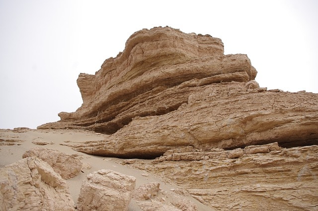
Mountains
There is no standard geological meaning for mountains. But it is usually defined as a landform that rises above anything around it, forming a steep slope and a pointed, relatively narrow summit. Generally, mountains are higher than hills. They are created through the action of incredible forces in the earth such as volcanic eruptions. Often, mountains in the deep ocean are higher and greater in size compared to the mountains standing on the land. Some of them are seen as islands in the middle of the vast profound as their peaks protrude out of the water. Mountain formation results from the forces of erosion, volcanism, or uplifts in the earth’s crust.
The forces of heat and pressure within the earth’s interior are the main influencing factors for these forces as stated by the geologists. These forces can be summed up as the plate tectonic movements – theoretically defined as the division of the earth’s outermost layer into several plates which are in constant motion. Hence, the uplifts are caused by collision or pulling apart of the plates that also triggers other various geological activities such as the ejection of magma onto the surface or volcanic eruptions.
The movements also contribute to horizontal compression that is the deformation of crustal strata which gives rise to folds. The Himalayas and Europe’s Jura and Alps mountains are examples of mountains that formed as a result of horizontal compression. Some mountain ranges are also formed as a result of wind, water, and ice erosion. Other mountains are created by volcanism.
Examples of volcanic mountains include Mount Fuji in Japan, Mount Vesuvius in Italy, Mount Erebus in Antarctica, and Mount Saint Helens in the United States. Majority of volcanic mountains have summit craters that still expel debris and steam.
Valleys
A valley is a lowland area or surface depression of the earth between higher lands such as mountains or hills. In simple terms, it can be defined as a natural trough bounded by mountains or hills on the surface of the earth sloping down to the lake, ocean or stream, which is created because of water or ice erosion. On this basis, the rivers or streams flowing through the valley act as the drainage system of the land, which channels the rainfall, snowfalls or waterfalls into the oceans.
The lowest parts of the valleys are very fertile and make very good farmlands. Majority of the valleys on land are made up of running streams and rivers and nearly all their floors slope downstream. Valleys within the mountains normally have narrow floors. The sides of a valley are termed as valley slopes or valley walls and the section of floor along riverbanks are referred to as flood plains.
The shape of a valley varies as the forces of erosion by the flowing masses that persistently widens and deepens the valley. The flowing masses are either water or glaciers that carry away huge amounts of debris. As a result, 3 types of shapes are seen in valleys, V-shaped, U-shaped and Flat-floored valleys. Very narrow and deep valleys are known as canyons.
Plateaus
Plateaus are one of the major landforms. These are supposed to be fairly flat areas sharply higher than the land surrounding it. Plateaus are existent in every continent and cover almost one third of the earth’s periphery. The Qinghai-Tibetan plateau, located in central Asia is the highest and the largest plateau in the world.
According to National Geographic, plateaus can be categorized into two types as per their formation, Dissected Plateaus and Volcanic Plateaus. Dissected plateaus form when two tectonic plates collide with each other and the earth’s crust keeps lifting upwards as a result of it. The Colorado plateau of the western USA is the greatest example of it. On the other hand, Volcanic plateaus form by numerous volcanic eruptions. The consecutive flow of lava builds the flat tabular structure over time. One example of this type of plateau is the North Island Volcanic Plateau of New Zealand. This island consists of three active volcanoes.
Low plateaus make up good farming regions whereas high plateaus are considered great for grazing livestock. Most of the world’s high plateaus are deserts. Other typical examples of plateaus include the Bolivian plateau in South America, the Colorado plateau of the United States, the Laurentian Plateau and the plateaus of Iran, Arabia, and Anatolia.
Glaciers
Glaciers are the perennial ice sheets on the planet. They are huge masses of ice that slowly move over the land or ocean surface. Glaciers are predominantly seen in the peaks of high mountains and in the cold Polar Regions. Low temperatures and consistent snowfall for millions of years in the regions are the enabling factors for the buildup of these massive ices at depths of 15 meters or even more. Most glaciers have density thickness in the ranges of 91 to 3000 meters. Antarctica’s Lambert Glacier is the largest and the fastest moving glacier in the world.
The movements begin when the compaction is so dense that it moves under the pressure of its weight. It is estimated that more than 75% of the world’s freshwater is currently locked in these frozen reservoirs. The glaciers include the Greenland Ice Sheet, the Antarctic Ice Sheet and the Canadian Arctic. The Antarctic Ice sheets outlet glaciers comprise the steep and extensively long and narrow depression of Beardmore Glacier. The gradual rise in continental temperatures is causing the glacial density to wane, resulting in melting.
Hills
Hills are raised landforms on the face of the earth with distinctive, usually rounded summits, but are not as high as mountains. The height of a hill on average never exceeds 300 meters or 1000 feet.
Hills are created as a result of accumulation of rock debris or sand deposited by wind and glaciers. They can also be created by faulting, when the faults go slightly upwards. Hills are generally present in low mountain valleys and plains.
The Black Hills are the most known. Deep erosions of areas previously raised by the earth’s crust disturbances carry most of the soil away leaving behind a hill. Human activities may also create hills when soils are dug and piled into giant masses. Volcanic eruptions create hills as well after the eruption. When the molten materials or lava cools and hardens in a pile it takes the shape of a giant swelling and is called hills.
Loess
Loess is a fine-grained unstratified accumulation of clay and silt deposited by the wind. It appears brown or yellow in color and is brought about by past glacial activities in an area. The thickness of loess deposits are just a few meters and one of their basic features is known as the ‘cat steps’.
It’s held together by few clay particles and is mostly composed of quartz crystals which readily slide against each other. This property makes it highly susceptible to erosion which leads to the ‘cat steps’ feature. Loess formed after the ice age when the glaciers covering a relatively large portion of the earth melted and were carried away, exposing the vast plains of mud.
Upon drying of the mud, the forces of wind blew away the mud and exposed sediments and eventually deposited them as silt in stacks on top of each other to create bold steep banks. Regions made of loess are witnessed in eastern China and the northwestern region of the United States.
Loess regions comprise 10% of the ground and are associated with semiarid, semi humid climate regimes. The Chinese deposit is said to be the thickest among all of the loess in the world. It is up to 300 m thick and is spread approximately 500 000 km2 .Loess regions are said to be one of the most fertile lands on earth. It is because of the silt particles.
Plains
Plains are broad flat areas on the earth’s surface stretching over a wide territory. They cover more than one-third of the total land area on earth. Plains are lower than the land in their surrounding and can be found both inland and along the coast. Coastal plains rise from the sea level up to the point where they meet raised landforms such as plateaus or mountains.The Atlantic Coastal plain is a prime example of a substantially populated and fertile coastal plain.
On the other hand, inland plains are generally found at high altitudes. Thick forests normally flourish on plains in humid climates. A fairly large portion of plains are covered by grasslands, for instance, the Great Plains in the United States. Human populations prefer settling on plains because of the soil and the terrain which is good for farming and building settlements such as cities, residential areas, and transportation networks. Flood plains are also in this category and they are formed as a result of continuous accumulation of sand, silt, and mud when rivers overflow its banks.
The famous plains are:
- Australian Plains, Australia.
- Canterbury Plains, New Zealand.
- Gangetic Plains of India, Bangladesh, North India,Nepal.
- Great Plains, United States.
- Indus Valley Plain, Pakistan.
- Kantō Plain, Japan.
- Nullarbor Plain, Australia.
- Khuzestan Plain, Iran.
Deserts
Deserts are the hot and dry areas of the world. They are the arid and semi-arid lands with little or no vegetation. Deserts constitute approximately 20% of the earth’s total land and are distinguished by little or zero rainfall. The deserts are divided into four major categories including the Semi-Arid Deserts, the Hot and Dry Deserts, the Cold Deserts, and the Coastal Deserts. However they are, all the deserts have one thing in common; and that is, rain pours down less than 10 inches here per annum.
These deserts are located in different areas of the world. Deserts experience very high temperatures, less cloud cover, low humidity, low atmospheric pressure, and very little rain, which makes them have very little vegetation cover. The soil is also rocky and shallow and with very little organic matter and as such, it only supports a few plants adapted to the conditions.
Plants such as cacti and short shrubs are the ones adapted to the desert conditions because they can conserve water and tolerate the high temperatures. Animals in the deserts include insects, small carnivores, snakes, lizards, and birds have been habituated to survive with very little water. These animals hide during the day till nightfall to avoid the heat. An example of a desert is the Sahara of North Africa.
Rivers
Rivers are the largest stream of water that flows through land and descend down to other water bodies like ocean, lake or other rivers. Rivers are not exactly landforms but parts of other landforms like mountains, prairies and valleys. The Mississippi and Missouri of the USA, The Nile of Egypt or The Ganges of India are good examples of Rivers.
Rivers are formed in different ways. Glacial eruptions, streams from the mountains or feeding from the lakes. The Nile is the longest river of the world, which flows over 6,650 km of land. The Amazon of South America is the second largest river and is 6,400 km long.
Though, rivers were created as results of different other landforms, they can cause changes or create landforms too. For example, in the upper course of rivers V-shaped valleys, rapids, gorges and waterfalls are created. In the middle course pools and riffles, natural levees and oxbow lakes are created. And in the lower course rivers create floodplains and deltas.
Oceans
Oceans are huge water sources. The reason for regarding oceans as landforms is its vastness; which covers three-fourth or 71% of the earth surface. During the degassing era, when the newly formed earth started to cool down, the hydrogen atoms inside the gas started to reform as rain water. These rainwaters poured down to the earth basins and filled it up, which we call oceans now. Ocean waters are salty and an enormous habitat for fishes and aquatic animals.
Ocean currents play a pivotal role in our lives. World climate and weather is completely dependent on it. Wind, density differences of water due to temperature and salinity, earth gravity, tide and events such as storms and earthquakes cause ocean currents. These currents move heat from equatorial parts to the polar regions. While moving, currents carry nutrients and foods to the organisms living in the ocean. Calculating ocean waves is important to the coastal communities, off-shore businesses and shipping routes.
The underwater landforms are tremendously gigantic and diverse. The mountains underneath are higher than Mount Everest, the largest mountain on the land. Mauna Kea, the highest underwater mountain in the Pacific Ocean, has been measured to be 10,200 m in height; whereas, Mount Everest is 8,848 m.