Sahara desert: Location, Weather, Temperature, and Countries That Sahara Desert Cover
Sahara is the World’s largest and most extensive hot desert located in North Africa. The Arabic word ṣaḥrāʾmeans “desert.” It ranks as the third largest desert after the cold deserts Antarctica and the Arctic. The desert covers an area of 3.6 million square miles (9.4 million square kilometers), which is nearly one-third of the African continent, and about the size of the US, including Alaska and Hawaii.
Location of Sahara Desert and the Countries it Covers
The Red Sea surrounds the Sahara on the east, the Atlantic Ocean on the west, on the north the Mediterranean Sea and the Sahel, a semi-arid tropical savannah of Sudan and the Valley of River Niger of Sub Saharan Africa on the south.
This gigantic desert is spread out in 11 countries: Algeria, Chad, Egypt, Libya, Mali, Mauritania, Morocco, Niger, Western Sahara, Sudan, and Tunisia.
Sahara holds very versatile features of the land that has been shaped by wind over time such as mountains, sand-dunes (erg), plateaus, barren stone plateaus (hamada), sand seas called ergs, sand-and gravel-covered plains (reg), basins, salt flats, dry valleys (wadis) and depressions.
The mountain ranges, many of which are volcanic, get more rainfall and cooler temperature than the rest. The highest point in the Sahara is Mount Koussi, an extinct volcano in Chad at 11,204 feet (3,415 m), is a part of the Tibesti Range in northern Chad. The deepest point in the Sahara is the Qattara Depression in Egypt at 436 feet (133 m) below sea level.
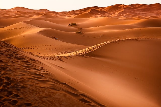
However, the Sahara desert is most famous for the fields of the sand dune that you see in movies. The dunes cover only about 15 percent of the entire desert but can reach up to 600 feet (183 meters) high.
The water is scarce across the entire desert. However, there are two permanent rivers-the Nile (originates in central Africa, flows northward through Sudan and Egypt and empties northwards into the Mediterranean Sea) and the Niger (originates in Western Africa, flows through Mali, then desert and Nigeria and empties into the Gulf of Guinea), minimum 20 seasonal lakes and vast underground reservoirs or aquifers. These are the primary sources of water in the 90 and more major desert oases.
Once the water management authorities feared that the aquifers would dry up soon due to overuse, however, a study published in 2013 in the journal Geophysical Research Letters, found the rain and runoff were still feeding the “fossil” (non-renewable) aquifers.
Weather and Temperature in Sahara
Sahara desert is the World’s hottest large land area. Two climatic regimes dominate the Sahara desert: a dry northern subtropical climate and a dry southern tropical climate. The characteristics of dry subtropical climate are unusually high-temperature ranges, annual and diurnal, hot summers and cold to cool winters, and two precipitation maximums.
The dry tropical climate, on the other hand, has a strong yearly temperature cycle following the declination of the sun; dry, mild winters; and a hot, dry season before the variable summer rains.
The climate is scorching hot and parched dry. The average summer temperatures in the day time are often 100.4F and 104.0°F (above 38 degrees Celsius) except for areas with high altitudes. The highest temperature that is recorded in the Sahara desert is at 136°F (58°C) in Aziziyah, Libya.
The Algerian Desert with an elevation of 1,240 feet above sea level, Salah in Algeria, a part of Sahara Desert also records high temperatures. The temperature can drop to near-freezing temperatures making the nights freezing cold. Occasionally, snow falls at higher elevations.
The skies are always cloudless clear in the Sahara Desert, and the sunshine duration can reach as high as for about 3600 hours to 4,300 hours of bright sunshine yearly, which is about 82% to 98% of the time. The highest sunshine duration is recorded in parts of Upper Egypt and around the Nubian Desert.
Precipitation ranges from zero to about 3 inches of rain per year in the Sahara. The rainfall is deficient in the northern and southern fringes of the desert, to almost zero rainfall in the eastern and central regions of the desert. There are also some locations devoid of rain for several years. The continuous exposure to high sunshine and very low humidity result in the lack of vegetative cover and almost no rainfall.
The northern fringes of the Sahara receive winter clouds and minimal average annual rainfall between 4 inches and 10 inches as a result of the low-pressure systems flowing through the Mediterranean Sea along the polar front. Few areas found in this zone include Ouarzazate in Morocco and Biskra in Algeria.
The southern fringes of the desert bordering the Sahel, receive summer clouds and here minimal average annual rainfall ranges from 4 inches to 10 inches due to the arrival of the Intertropical Convergence Zone, ITCZ. The zone includes Agadez in Niger and Timbuktu in Mali.
Most of the central Sahara receives almost zero rain being unaffected by the southerly or the northerly atmospheric variance. It is under the constant influence of the anticyclonic weather patterns. In this zone, the average annual rainfall can drop to as low as 0.04 inches.
In 2019 a study published in the Journal Science Advances disclosed an amazing fact that the Sahara has alternate cycles of one dry, inhospitable desert and another lush, green oasis in about every 20,000 years. The marine sediments containing dust deposits from the Sahara over the past 240,000 years were examined by the authors of the study.
The team found that slight changes in the tilt of Earth’s axis cause the cycle between a dry and a green Sahara which also drives monsoon activity. When the axis of the Earth tilted just a single degree closer to the sun in the Northern Hemisphere that is about 24.5 degrees instead of 23.5 degrees now, it received more sunlight increasing the monsoon rains and therefore, supporting a lush green landscape in the Sahara.
The archaeological discovery of prehistoric cave and rock paintings and other archeological remains give an idea about life in the once-green Sahara. The bits of pottery suggest that ancient herders raised livestock and harvested plants about 7,000 years ago, which is now an arid desert.
The climate of the Sahara has been relatively stable for the last 2,000 years. The powerful and capricious winds from the northeast dry out the air over the desert and drive hot winds toward the equator. These winds cause severe dust storms due to their exceptional speeds, and local visibility becomes zero. Dust travels on trade winds all the way from the Sahara to the opposite side of the globe.
Climate Change Effects on Sahara
The Sahara desert has grown about 10% in size since 1920, according to a 2018 study published in the Journal of Climate. Usually, all deserts increase in the area during the dry season and decrease during the wet season, similar to what happened in Sahara. However, human-caused climate change intervenes with natural climate cycles and causes the Sahara to grow more and shrink less. Approximately one-third of the expansion in the desert was due to the human-made climate change as per the estimation of the study’s authors.
The best way for mitigating the effects of climate change is to install wind and solar farms in large-scale in the Sahara. The wind and solar farms would provide clean energy while reducing the amount of greenhouse gases entering the atmosphere. It may also help in increased precipitation in the vicinity according to the 2018 study published in the journal Science Advances.
The wind farm simulations showed that there would be warmer temperatures in areas with wind farms, due to the wind turbines, especially at night as they would bring warm air to the surface from higher in the atmosphere. As per the estimation of the researchers, the precipitation over the wind farms would double on average, which would increase vegetation by an estimated 20 percent. The solar farm simulations also generated similar results.
A large-scale wind farm in Sahara would produce approximately 3 terawatts of electrical power as predicted by the study authors, while a large Saharan solar farm would produce about 79 terawatts exceeding the electrical power of 18 terawatts that were consumed in 2017. The extra energy so produced could be utilized for more large-scale projects, including increased agriculture and water desalination.
Sources: